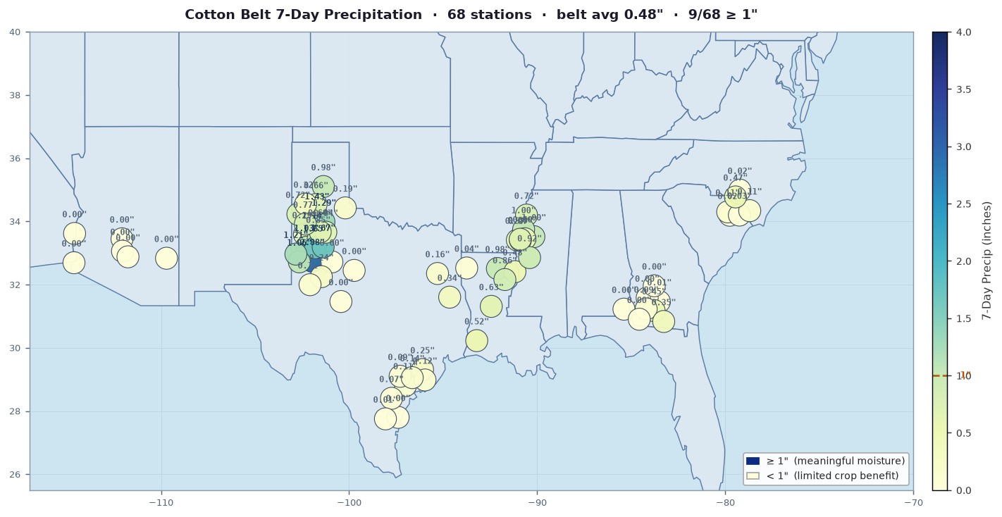
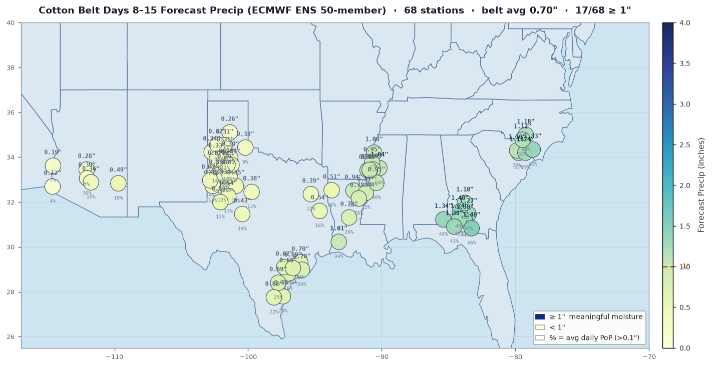
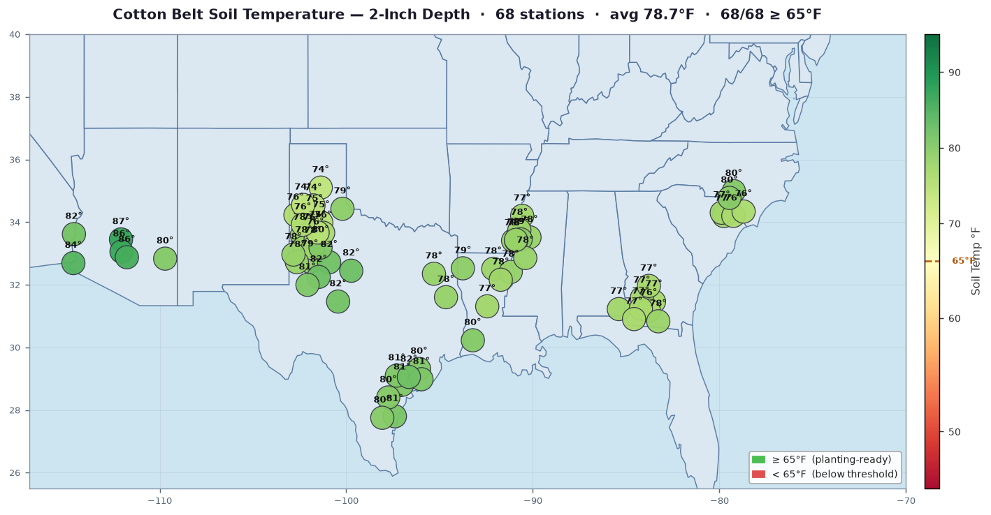
VLM Commodities Ltd — Live Market Intelligence
The single most important weather story in the US cotton belt this week is the D4 exceptional drought gripping Georgia and the Southeast at the onset of planting, where 2-inch soil temperatures of 87°F and only 0.2 inches of precipitation over the past seven days are leaving dryland acres without the seedbed moisture needed for reliable germination — and we believe a failed or severely delayed plant stand across Georgia production at this stage carries abandonment risk that the market has not yet fully priced. We have said for several weeks that the Southeast was the region to watch given the persistence of D3-D4 conditions, and while the acreage footprint is smaller than West Texas, the quality reputation of Georgia fiber means any meaningful reduction in Southeast supply tends to carry an outsized basis and classing implication relative to the lost bale count alone. Compounding the supply picture, West Texas dryland acres are entering planting under D2-D3 drought with only 0.3 inches of precipitation across 24 stations and ET demand running at 0.3 inches per day, a deficit pace that, if it holds through late May, will in all likelihood push Southwest abandonment expectations meaningfully above the ten-year average and represent the more structurally bearish argument against — the one factor that makes the current setup net bullish for December futures in our opinion. We think the combination of drought-stressed planting conditions in both the Southeast and West Texas, at a moment when the entire US belt is simultaneously in the ground, makes this a week where commercial on-call sales are likely to slow and any sustained break toward support will attract grower reluctance to price new crop — a setup that leans supportive for the December contract barring a material shift in the seven-day precipitation outlook.
We have been watching what amounts to a belt-wide planting stress situation develop in real time, and the station data confirms what the surface analysis has been suggesting for the better part of two weeks — meaningful precipitation is reaching very few of the acres that need it most. The most alarming signal in this morning's data is out of Georgia and the Southeast, where the 2-inch soil temperature is already running 87°F with only 0.2 inches of 7-day precipitation against a D4 drought designation covering a meaningful portion of the acreage; at planting, germination and seedling emergence depend critically on adequate soil moisture in that top profile, and we believe D4 conditions at this stage represent a genuine threat to stand establishment that, if it persists another ten days, will begin showing up in poor-to-fair crop condition ratings and ultimately in upward pressure on abandonment estimates for what is normally a reliably productive part of the belt. West Texas is not generating the headline drought number Georgia is, but D2-D3 coverage across dryland planting acres with only 0.3 inches of 7-day precipitation and soil temperatures already at 92.5°F — well above the 65°F threshold for acceptable cotton germination and uncomfortably close to the range where rapid soil moisture evaporation compounds seedling stress — tells us that growers pressing dryland acres into the ground right now are doing so on faith rather than on moisture, and the Southwest production story for 2026 could get difficult to tell by mid-May if the ridge that has been suppressing Gulf return flow does not break down. The one region offering any relief from the drought narrative is the Mississippi Delta, where 1.6 inches of 7-day precipitation and an 80°F soil temperature present conditions we would characterize as close to optimal for planting — though we note D2-D3 drought classifications persist there as well, suggesting that last week's rain events are ameliorating but not resolving the underlying moisture deficit, and Delta merchants will be watching whether commercials begin adjusting on-call purchase structures if
We believe the most consequential precipitation signal over the next seven days sits squarely over the Mississippi Delta and portions of East Texas and Louisiana, where 2-inch soil temperatures are already running near 80°F and the planting window is active — the Delta's 1.6 inches of seven-day accumulation to date suggests moisture is not the limiting factor there, and any additional rainfall from the Gulf moisture train that the GFS, ECMWF, and NBM all appear to agree is tracking through that corridor would push some fields past optimal planting conditions and introduce the first gin scheduling and field access concerns of the season, even if it is too early to call it abandonment risk. The sharp divergence between models emerges in West Texas and South Texas, where the dryland planting situation is already stressed under D2 and D3 drought designations and only 0.3 inches of precipitation has fallen across 24 stations in the prior seven days — the GFS has been periodically advertising a mid-period Plains shortwave that would deliver measurable rainfall to the Rolling Plains, but the ECMWF continues to suppress that signal and push the moisture axis eastward, and the NBM, splitting the difference as it often does in May, is offering probabilities that would not move a grower's needle unless they resolve sharply higher; in our opinion, until that disagreement closes, the dryland planting situation in Southwest production should be treated as deteriorating, not recovering, and every day without germinating rainfall past optimal soil temperature windows tightens the effective abandonment calculus for the acres already in the ground. Georgia and the Southeast concern us perhaps more than the headlines suggest — D4 drought at the 2-inch soil temperature level of 87°F during active planting, with only 0.2 inches observed and model consensus notably weak on any meaningful relief over the next week, means that emergence on dryland acres there is going to be uneven at best, and we have said consistently that stressed stands at emergence create a compounding quality risk that doesn't show up in crop condition ratings for several weeks, by
We believe the most urgent signal in the medium-range guidance is the near-total absence of meaningful precipitation relief across the Southeast and Carolinas, where 2-inch shallow soil temperatures are already running at 87°F and drought classifications reach D4 in Georgia — the kind of extreme moisture deficit at planting that forces seed into dry seedbeds and dramatically elevates the risk of poor emergence rates and uneven stands, conditions that historically translate into patchy crop condition ratings by early June and early abandonment pressure on marginal dryland acres before the crop even squares. The Delta, which has received 1.6 inches over the past seven days and sits in D2/D3 despite that recent moisture, appears to have the most tolerable planting window in the belt right now, though we would caution that even there the underlying drought structure has not broken and any return to dryness in the next three to four weeks — well within the medium-range envelope — would stress a young crop before roots are established. West Texas and South Texas concern us perhaps most from a market perspective: with 2-inch soil temperatures above 90°F, only 0.3 inches of seven-day rainfall, and persistent D2/D3 drought baked into the landscape heading into what is already a compressed planting window, any Days 3–7 guidance that shows continuation of the current dry, high-pressure-dominated pattern rather than a pattern change would, in our opinion, begin to materially threaten dryland planting intentions and lift the probability of pre-season abandonment on the most marginal Rolling Plains acres — a development that would be difficult for the trade to ignore if it shows up in the May WASDE acreage revisions. Arizona emergence under D1/D2 conditions is the one situation we think is most manageable near-term given that irrigated Pima acres can backstop soil moisture deficits, but we do feel the broader belt-wide dryness story, if the medium-range confirms no credible pattern change through at least May 12th, is structurally supportive for December futures
We have been watching the extended ensemble guidance closely this week, and we think the honest answer is that the pattern beyond Day 7 offers very little comfort to the regions that need it most — the D4 conditions across Georgia and the Southeast represent the most acute concern on our map right now, and the 8-to-14 day signal from both the GFS and ECMWF ensembles carries a decidedly dry bias for the southern half of the belt, with above-normal 500-hPa heights anchoring over the Gulf Coast and suppressing organized convective moisture delivery into Georgia, the Carolinas, and South Texas precisely when these dryland acres need germination moisture to advance emergence on any planting that has gone in under stress. The Delta is the one region where we see a modestly wetter-than-normal signal in the extended window — the 1.6 inches recorded over the past seven days there is already creating planter traffic concerns, and if ensemble means verify even partially, Delta producers face the uncomfortable calculus of planting into adequate-to-excessive moisture while their ginning infrastructure from last season's pace is still being reset for the new crop year. Confidence in any Day 8-through-14 precipitation signal is, in our opinion, materially lower than normal this week because the large-scale ridge responsible for the dry bias across the Southeast is itself a contested feature in the ensemble spread, meaning the dry scenario is probable but not lockable — we would assign perhaps 55-to-60 percent probability to below-normal precipitation continuing across Georgia and the Carolinas through mid-May, which is meaningful but not the kind of certainty that justifies aggressive irrigation pre-scheduling or, conversely, allows a grower to confidently defer planting in hopes of a pattern break. For Arizona irrigated cotton now at emergence, the dry signal is operationally irrelevant given fully managed water delivery, but ET demand at 0.2 inches per day against only 0.1 inches of seven-day precip confirms that canal and well scheduling should be running at normal early-season rates with
We want to be direct on the heat stress question: with essentially the entire US cotton belt still in the planting window as of early May, there are no bolls setting or filling anywhere across the belt right now, and Arizona — the one region at emergence — is running a cool 61.9°F average with soil temps in the mid-80s at two inches, so heat stress on reproductive structures is simply not a present concern for any region this week. On the frost question, the Carolinas and Georgia-Southeast are equally irrelevant for open boll frost exposure at this stage — no open bolls exist, and with 2-inch soil temps already at 87°F in the Carolinas and 87°F in the Southeast, the late-season frost discussion is months away, though we will note with some concern that Georgia's D4 drought conditions at planting are an inauspicious start that could compress the growing season if replanting becomes necessary on moisture-failed stands, ultimately pushing maturity later and increasing frost exposure risk on a calendar basis come October. The GDD picture is what we think deserves the most attention right now: West Texas is running a 64.5°F average air temperature against soil temps of 92.5°F at two inches, which tells us surface energy is building but cool nights are still moderating the thermal accumulation profile, and across the Delta at 63.7°F average — despite 1.6 inches of weekly precipitation providing the best planting-window moisture of any region in the belt — the GDD pace is likely running modestly behind a normal trajectory for early May, implying that if this coolness persists through the squaring window in July, defoliation timing could slip from a typical late-September target toward early-to-mid October, a shift that is not catastrophic in itself but that materially increases the statistical probability of weather interference during harvest across the Southeast and Carolinas specifically.
We have been watching this drought footprint expand with considerable concern, and the current picture across the belt is, in our opinion, one of the more troubling planting-window setups we have seen in several years — virtually every major production region is carrying D2 or worse drought designation, with Georgia and the Southeast reporting D4 conditions at the extreme end, the Carolinas sitting at D3, West Texas and South Texas both straddling D2-D3 coverage, and even the Delta, which received 1.6 inches over the past seven days, remaining mired in D2-D3 territory that one week of moderate rainfall will not meaningfully resolve. The West Texas and Rolling Plains situation warrants the sharpest focus from a supply standpoint: with 2-inch soil temperatures averaging 92.5°F across our 24 station network — readings that are warm enough to encourage seed germination in theory — the practical reality is that with only 0.3 inches of 7-day accumulation against an ET demand running at 0.3 inches per day, the region is losing moisture faster than it is receiving it, and dryland acres going into D2-D3 soils at planting are not starting from a position that tolerates additional stress without abandonment risk materializing well before squaring, a dynamic that we believe the market is underpricing in the current futures structure given that West Texas dryland represents the single largest source of production uncertainty in the entire US belt. Arizona's emergence-stage crop is operating under D1-D2 drought, and while that irrigated system has the delivery infrastructure to compensate, ET demand at 0.2 inches per day against only 0.1 inches of precipitation over the past week means irrigation sets over the coming two weeks will need to be both timely and adequate to protect uniform emergence and early root development — water cost and scheduling pressure on that system should not be dismissed, though we do feel the quality risk there is manageable compared to what dryland West Texas faces. Taken together, the breadth of this drought footprint — D2
We have no open bolls or crops approaching harvest anywhere in the belt at this moment — every US region is at planting or early emergence — so the traditional concern about rainfall-driven grade damage, bark contamination, or harvest delay does not apply this week, but convective risk during planting is still a meaningful market signal because hail and flooding can compact soils, erode seed furrows, and force replant decisions that shorten the effective growing season on already-stressed dryland acres. Based on SPC and WPC guidance valid through May 8th, the most consequential convective threat we are watching sits across the Southern Plains and into the Rolling Plains of West Texas, where a series of upper-level disturbances rotating through an amplified trough pattern are capable of producing organized severe convection — including hail to two inches or larger and damaging straight-line winds — over dryland acres already carrying D2 and D3 drought designations with only 0.3 inches of seven-day precipitation recorded against an ET demand environment that, while modest at 0.3 inches per day for the season, reflects soils that have not recovered meaningfully heading into what is arguably the most critical planting window for Southwest production. We do feel that any hail events on freshly planted West Texas dryland ground would force replant on affected fields, effectively compressing the planting window further into May and raising the probability that late-planted bolls encounter heat stress during August boll fill — a sequence the market has seen translate into elevated abandonment rates and micronaire problems on the back end of the season, both of which are ultimately supportive for nearby futures if the acreage loss is confirmed in subsequent crop condition ratings. Separately, the Delta is showing 1.6 inches of seven-day precipitation against D2 and D3 background drought, and while that moisture is broadly welcome for planting progress, WPC guidance suggests additional convective rainfall of one to two inches is possible across the lower Mississippi Valley in the next 72 hours, raising the prospect of localized ponding and field saturation that could delay final planting
We believe the seasonal setup entering this planting window carries a meaningfully bearish supply risk that the futures market may not yet be fully pricing, and we say that with particular conviction about the Southwest production region where West Texas 2-inch soil temperatures are reading an anomalously warm 92.5°F against only 0.3 inches of 7-day precipitation across a landscape already degraded to D2 and D3 drought classification — conditions that historically suppress planting confidence on dryland acres and will force growers into a difficult calculus between putting seed in dry ground and waiting on moisture that the seasonal models do not convincingly promise. The ENSO state as we move through spring 2026 is tracking toward a weak La Niña decay or ENSO-neutral transition, and while that sound-byte tends to read as benign, the CPC 30-day and 3-month outlooks have consistently maintained an above-normal temperature probability and equal-to-below-normal precipitation probability across the Southern Plains and much of the Southeast through the JJA period — which maps almost exactly onto the critical squaring and early boll fill window for West Texas and the Carolinas, and which, if verified, would sustain or worsen the abandonment trajectory we are already inclined to worry about given the D4 drought signature sitting across Georgia and the D3 coverage in the Carolinas before a single boll has been set. The ECMWF monthly ensemble guidance, which we weight heavily for its handling of soil moisture memory and its tendency to outperform GFS on multi-week temperature anomalies, has been leaning persistently warm and dry across the Texas Cotton Belt through at least mid-June, and while forecast skill degrades meaningfully beyond three weeks, the persistence of that signal across multiple ensemble cycles suggests this is not noise — it appears to reflect genuine atmospheric forcing that growers and merchants alike should treat as the base case rather than a tail risk when thinking about dryland yield potential and abandonment rates later this summer. Against this backdrop, we think the cotton merchant who is sitting on unpriced physical
Weather analysis loading…
cached
**West Texas:** With only 0.3" of precipitation over the past seven days against D2–D3 drought already established across the region, dryland planting in West Texas is proceeding into profile moisture deficits that, in our opinion, represent the most consequential agronomic setup in the belt right now — and while the 2-inch soil temperature reading of 92.5°F is anomalously warm and would ordinarily support rapid germination, we are frankly skeptical that adequate seedbed moisture exists on enough dryland acres to convert planting intentions into a stand without a meaningful rainfall event in the next two to three weeks. **South Texas:** South Texas mirrors the severity of the West Texas moisture story, with D2–D3 drought conditions and just 0.3" of seven-day accumulation doing nothing to rebuild profile moisture, and the 90.6°F soil temperature at 2 inches tells us thermal conditions are favorable for germination wherever moisture exists — but the operative phrase is "wherever moisture exists," and on dryland acres in Nueces and adjacent counties, we believe abandonment risk is already pricing into grower psychology before a meaningful stand has even been established. **East TX / Louisiana:** This sub-region is the relative bright spot in the Texas–Louisiana corridor this week, with 0.7" of seven-day precipitation providing at least some seedbed moisture relief against an otherwise D2–D3 drought backdrop, and the cooler average temperature of 68.0°F combined with a 79.5°F soil temperature suggests conditions that are adequate if not ideal for planting — we would characterize this region as marginally workable rather than stressed, though the underlying drought classification reminds us the profile moisture bank remains in deficit. **Mississippi Delta:** The Delta recorded 1.6" of precipitation over the past seven days, making it the wettest region in the belt this week by a considerable margin, and while that precipitation is broadly welcome against a D2–D3 drought background, we would note that cool average temperatures of 63.7°F and a
| Station | ST | Temp °F | Hi/Lo | Today Precip" | 7-Day Precip" | ET₀ in/day | Wind mph | Soil 2" °F | Drought | Conditions | 7-Day |
|---|---|---|---|---|---|---|---|---|---|---|---|
| Lubbock | TX | 69.8 | 83.9/67.9 | 0.00 | 0.19 | 0.32 | 20.4 | 94.7 | D2 | Partially cloudy | |
| Lamesa | TX | 62.6 | 85.9/65.4 | 0.00 | 0.38 | 0.33 | 35.5 | 86.8 | D2 | Clear | |
| Levelland | TX | 69.9 | 81.9/65.0 | 0.00 | 0.03 | 0.33 | 25.1 | 101.8 | D2 | Partially cloudy | |
| Brownfield | TX | 66.7 | 83.9/65.9 | 0.00 | 0.21 | 0.33 | 29.0 | 84.0 | D2 | Partially cloudy | |
| Plainview | TX | 62.5 | 80.0/63.1 | 0.00 | 0.16 | 0.25 | 22.0 | 93.1 | D2 | Clear | |
| Slaton | TX | 69.9 | 85.0/67.0 | 0.00 | 0.33 | 0.32 | 27.1 | 91.6 | D2 | Partially cloudy | |
| Tahoka | TX | 67.9 | 85.9/65.0 | 0.00 | 0.28 | 0.33 | 25.7 | 90.2 | D2 | Partially cloudy | |
| Seminole | TX | 65.1 | 83.9/65.6 | 0.00 | 0.83 | 0.32 | 24.6 | 77.3 | D2 | Clear | |
| Snyder | TX | 63.4 | 90.1/64.3 | 0.00 | 0.52 | 0.35 | 25.3 | 101.3 | D2 | Clear | |
| Post | TX | 70.1 | 88.1/67.9 | 0.00 | 0.48 | 0.37 | 25.5 | 97.9 | D2 | Partially cloudy | |
| Big Spring | TX | 64.8 | 89.0/64.9 | 0.00 | 0.56 | 0.38 | 23.3 | 100.9 | D2 | Clear | |
| Abilene | TX | 69.7 | 92.9/68.4 | 0.00 | 0.48 | 0.33 | 16.6 | 98.6 | D0 | Clear | |
| San Angelo | TX | 67.0 | 94.0/66.8 | 0.00 | 0.31 | 0.31 | 14.9 | 101.0 | None | Clear | |
| Midland | TX | 67.3 | 88.1/66.6 | 0.00 | 0.13 | 0.35 | 21.7 | 102.6 | D2 | Clear | |
| Childress | TX | 66.3 | 78.2/56.9 | 0.00 | 0.11 | 0.24 | 20.4 | 77.6 | D2 | Clear | |
| Floydada | TX | 58.9 | 81.1/63.9 | 0.00 | 0.18 | 0.24 | 17.2 | 88.1 | D2 | Clear | |
| Crosbyton | TX | 61.0 | 83.9/68.8 | 0.00 | 0.15 | 0.28 | 16.9 | 88.0 | D2 | Partially cloudy | |
| Lorenzo | TX | 68.0 | 83.0/69.0 | 0.00 | 0.20 | 0.29 | 22.0 | 89.8 | D2 | Partially cloudy | |
| Denver City | TX | 65.8 | 81.1/64.7 | 0.00 | 0.89 | 0.30 | 26.4 | 75.0 | D2 | Clear | |
| Muleshoe | TX | 55.9 | 81.1/61.2 | 0.00 | 0.09 | 0.29 | 20.9 | 102.8 | D2 | Overcast | |
| Claude | TX | 52.7 | 74.8/52.1 | 0.00 | 0.08 | 0.24 | 21.3 | 80.4 | D3 | Clear | |
| Tulia | TX | 58.5 | 76.9/58.0 | 0.00 | 0.13 | 0.25 | 19.4 | 90.3 | D3 | Clear | |
| Dimmitt | TX | 54.3 | 79.1/58.2 | 0.01 | 0.04 | 0.27 | 18.9 | 101.3 | D3 | Clear | |
| Littlefield | TX | 69.9 | 81.1/63.9 | 0.00 | 0.12 | 0.30 | 23.7 | 104.3 | D2 | Partially cloudy |
| Station | ST | Temp °F | Hi/Lo | Today Precip" | 7-Day Precip" | ET₀ in/day | Wind mph | Soil 2" °F | Drought | Conditions | 7-Day |
|---|---|---|---|---|---|---|---|---|---|---|---|
| Corpus Christi | TX | 76.4 | 81.1/73.3 | 0.00 | 0.30 | 0.16 | 16.2 | 92.6 | D2 | Overcast | |
| Victoria | TX | 73.0 | 87.0/68.2 | 0.01 | 0.28 | 0.10 | 13.8 | 90.2 | D3 | Partially cloudy | |
| Beeville | TX | 73.0 | 90.9/69.5 | 0.00 | 0.35 | 0.16 | 16.0 | 93.1 | D3 | Overcast | |
| Alice | TX | 74.9 | 94.0/70.1 | 0.00 | 0.29 | 0.22 | 15.6 | 96.2 | D2 | Overcast | |
| Wharton | TX | 73.3 | 85.0/68.5 | 0.02 | 0.37 | 0.10 | 16.2 | 86.3 | D3 | Overcast | |
| Bay City | TX | 74.9 | 83.9/72.2 | 0.02 | 0.43 | 0.12 | 17.3 | 87.6 | D3 | Overcast | |
| Cuero | TX | 73.1 | 88.1/69.4 | 0.00 | 0.36 | 0.15 | 14.7 | 89.7 | D3 | Partially cloudy | |
| Edna | TX | 74.6 | 85.9/70.1 | 0.03 | 0.30 | 0.10 | 14.4 | 89.3 | D3 | Partially cloudy |
| Station | ST | Temp °F | Hi/Lo | Today Precip" | 7-Day Precip" | ET₀ in/day | Wind mph | Soil 2" °F | Drought | Conditions | 7-Day |
|---|---|---|---|---|---|---|---|---|---|---|---|
| Tyler | TX | 69.3 | 85.0/68.0 | 0.01 | 0.08 | 0.23 | 20.8 | 81.3 | D3 | Overcast | |
| Nacogdoches | TX | 69.6 | 85.0/66.8 | 0.00 | 0.28 | 0.17 | 17.8 | 79.6 | D2 | Overcast | |
| Shreveport | LA | 69.7 | 85.0/67.9 | 0.00 | 0.52 | 0.20 | 17.7 | 79.8 | D3 | Partially cloudy | |
| Alexandria | LA | 67.1 | 83.0/61.4 | 0.02 | 0.23 | 0.10 | 13.0 | 79.6 | D3 | Overcast | |
| Monroe | LA | 66.0 | 83.0/64.9 | 0.00 | 2.13 | 0.12 | 14.6 | 76.1 | D3 | Overcast | |
| Tallulah | LA | 64.3 | 83.0/59.1 | 0.00 | 1.07 | 0.10 | 19.1 | 79.6 | D3 | Overcast | |
| Lake Charles | LA | 73.1 | 81.9/66.0 | 0.02 | 0.19 | 0.12 | 14.7 | 81.8 | D2 | Partially cloudy | |
| Winnsboro | LA | 65.2 | 81.9/62.2 | 0.00 | 0.75 | 0.09 | 16.0 | 78.1 | D3 | Overcast |
| Station | ST | Temp °F | Hi/Lo | Today Precip" | 7-Day Precip" | ET₀ in/day | Wind mph | Soil 2" °F | Drought | Conditions | 7-Day |
|---|---|---|---|---|---|---|---|---|---|---|---|
| Greenville | MS | 64.0 | 81.9/61.2 | 0.00 | 1.12 | 0.10 | 15.7 | 77.7 | D3 | Overcast | |
| Greenwood | MS | 64.0 | 81.9/58.9 | 0.01 | 2.60 | 0.11 | 15.2 | 81.2 | D3 | Clear | |
| Clarksdale | MS | 63.4 | 80.0/63.1 | 0.02 | 0.95 | 0.14 | 19.2 | 76.6 | D3 | Partially cloudy | |
| Cleveland | MS | 64.7 | 81.1/62.3 | 0.00 | 1.76 | 0.12 | 18.8 | 80.5 | D3 | Partially cloudy | |
| Indianola | MS | 64.4 | 81.9/61.2 | 0.00 | 1.44 | 0.12 | 20.3 | 84.7 | D3 | Overcast | |
| Leland | MS | 63.4 | 81.9/61.1 | 0.00 | 1.46 | 0.10 | 16.8 | 80.3 | D3 | Overcast | |
| Yazoo City | MS | 63.0 | 81.1/58.1 | 0.00 | 2.69 | 0.15 | 14.9 | 80.1 | D2 | Clear | |
| Stoneville | MS | 62.7 | 80.0/61.1 | 0.00 | 1.09 | 0.10 | 16.9 | 80.3 | D3 | Overcast |
| Station | ST | Temp °F | Hi/Lo | Today Precip" | 7-Day Precip" | ET₀ in/day | Wind mph | Soil 2" °F | Drought | Conditions | 7-Day |
|---|---|---|---|---|---|---|---|---|---|---|---|
| Tifton | GA | 65.0 | 83.9/54.9 | 0.00 | 0.16 | 0.24 | 10.3 | 86.8 | D4 | Clear | |
| Albany | GA | 60.7 | 83.9/51.3 | 0.00 | 0.04 | 0.24 | 9.6 | 81.3 | D4 | Clear | |
| Cordele | GA | 65.0 | 83.9/50.6 | 0.00 | 0.07 | 0.25 | 10.7 | 90.7 | D3 | Clear | |
| Moultrie | GA | 64.2 | 83.0/54.0 | 0.00 | 0.50 | 0.24 | 11.4 | 86.3 | D4 | Clear | |
| Dothan | AL | 62.0 | 83.0/50.5 | 0.00 | 0.16 | 0.22 | 10.4 | 88.1 | D4 | Clear | |
| Camilla | GA | 59.5 | 83.9/52.9 | 0.00 | 0.35 | 0.25 | 10.6 | 89.9 | D4 | Clear | |
| Bainbridge | GA | 60.8 | 85.0/52.1 | 0.00 | 0.09 | 0.23 | 9.5 | 88.5 | D4 | Clear | |
| Valdosta | GA | 66.0 | 85.9/52.6 | 0.00 | 0.62 | 0.23 | 9.3 | 84.2 | D4 | Clear |
| Station | ST | Temp °F | Hi/Lo | Today Precip" | 7-Day Precip" | ET₀ in/day | Wind mph | Soil 2" °F | Drought | Conditions | 7-Day |
|---|---|---|---|---|---|---|---|---|---|---|---|
| Florence | SC | 62.5 | 81.1/48.1 | 0.00 | 0.30 | 0.25 | 14.2 | 90.9 | D3 | Clear | |
| Darlington | SC | 66.1 | 81.1/49.9 | 0.00 | 0.43 | 0.25 | 13.4 | 91.1 | D3 | Clear | |
| Mullins | SC | 63.2 | 80.0/51.4 | 0.00 | 0.53 | 0.24 | 14.9 | 86.7 | D3 | Clear | |
| Whiteville | NC | 66.0 | 80.0/50.0 | 0.00 | 0.30 | 0.23 | 14.8 | 83.5 | D3 | Clear | |
| Raeford | NC | 63.0 | 83.0/53.6 | 0.00 | 0.70 | 0.26 | 14.4 | 83.9 | D3 | Clear | |
| Laurinburg | NC | 62.2 | 81.9/51.9 | 0.00 | 0.48 | 0.26 | 14.2 | 86.9 | D3 | Clear |
| Station | ST | Temp °F | Hi/Lo | Today Precip" | 7-Day Precip" | ET₀ in/day | Wind mph | Soil 2" °F | Drought | Conditions | 7-Day |
|---|---|---|---|---|---|---|---|---|---|---|---|
| Phoenix | AZ | 65.9 | 78.0/63.9 | 0.30 | 0.30 | 0.22 | 13.0 | 87.1 | D2 | Partially cloudy | |
| Maricopa | AZ | 64.2 | 76.9/61.1 | 0.03 | 0.03 | 0.26 | 15.6 | 90.6 | D2 | Overcast | |
| Casa Grande | AZ | 65.3 | 74.9/60.0 | 0.17 | 0.17 | 0.21 | 14.5 | 86.1 | D2 | Overcast | |
| Yuma | AZ | 59.6 | 78.0/58.9 | 0.00 | 0.00 | 0.25 | 15.2 | 88.5 | D1 | Clear | |
| Safford | AZ | 56.4 | 74.9/56.0 | 0.07 | 0.07 | 0.24 | 20.5 | 73.8 | D2 | Rain, Partially cloudy | |
| Blythe | CA | 60.0 | 79.1/54.1 | 0.00 | 0.00 | 0.27 | 14.2 | 91.7 | D0 | Clear |